The Shipping Technology of Cholas
by K.V. Ramakrisna Rao, IndiaInteracts, November 1, 2007
|
[A] critical study is made in this paper to analyze the shipping, shipbuilding and naval capabilities of the Cholas.
|
Unfortunately in our original source for this article neither the references, nor the Tamil script survive. We would be very happy to receive a link to a version which includes both, as much is lost without them.
Introduction:
Of late, some researchers [1] have started throwing doubt on the overseas expedition of Rajaraja Chola through Rajendra Chola on the plea that the Parasasti / Meikkirti could have been written with poetic fantasy rather than the factual accuracy. Even, had Rajendra Cholan gone there, it could have been only a raid to loot and not to set foot as a conqueror! Earlier Aidan Southhall [2] analyzed the West African politics in terms of the “segmentary states theory" and applied to medieval European states. Burton Stein [3] applied such model to South India, though Bernard S. Cohn [4] opposed. Burton, then applied such theory to Cholas and George W. Spencer [5] accepting it to declare that in such “segmentary states", the state"s functions were custodial rather than regulative, magico-ritualistic rather than managerial. Thus Cholas resorted to the policy of “plunder and piety" just like Frankish kings of early mediaeval Europe. Rajaraja too fulfilled his charitable obligations – his “necessary giving" – in an extravagant way, aggressively acquiring booty only to donate more lavishly to temples and Brahmans. In such an attempt, the Tanjore inscriptional details of Cholas expedition to South East Asian Countries are dubbed as mere rhetoric. All these continue, though R. C. Majumdar [6] after discussing the “struggle between the Silendras and the Cholas", long back pointed out, “That the story of this victory is not merely an imagination of the court-poets, but based on facts, is proved, beyond doubt, by the detailed references to the vassal states. It is interesting to note that many of these States are included in the Silendra Empire by later Chinese authorities".
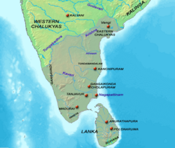 |
Center of Chola Empire ~ 1100 |
Though, non-Indian researchers point out the maritime activities [7], international trade, import and export of goods, movement of people-groups with religious beliefs [8] etc., their studies have been restricted to Chinese, Arabic and European exploits or impact with passing remarks to Indians and Cholas.
Accepting the fact of Indian goods, people, their religion, temple-building technology etc., going there, but doubting their mode of travel appears illogical and unhistorical. Therefore, a critical study is made in this paper to analyze the shipping, shipbuilding and naval capabilities of the Cholas.
Whether Naval battles were fought or not?
The core is dealt with
The concept of oversea expedition and conquer is linked with Naval battles so that the incoming warriors from the ships land and enter into cities so that the conquest is complete. The critical observations made by different researchers are mentioned as follows:
George W. Spencer [9]: “In spite of several references in Tanjore record to ships and bodies of water, there is nothing in those purely rhetorical references that requires us to believe that Cholas fought naval battles. Indeed, the equally conventional reference to capturing the Kedah elephants would suggest land battles".
Moti Chandra [10] succinctly describes the Cholas expedition to SEA concluding as follows: “In the conquests of Rajendra Chola came almost the whole eastern part of Sumatra, and the central and southern parts of the Malay peninsula. He also occupied the capitals of Srivijaya and Kedah. Perhaps this expedition started in 1025 A.D". Significantly, in next the line, he poses the issue:
“The Indian literature does not mention many sea battles. Therefore, we are surprised to read the description of an Indian fleet in Tilakamanjari [11] of Dhanapala [12]. The story mentions that an Indian prince, Samaraketu of Rangasala, led this Indian fleet. He led this expedition to Indonesia because the feudatory chiefs there refused to pay the tributes and taxes in time………….” Surprised by the close similarity between the narration about Cholas naval expedition and the Tilakamanjari story, he notes:
“Whether the sea expedition described in the Tilakamanjari gives glimpses of the victorious expedition of Rajendra Chola, or some other Indian ruler, depends on the exact date of Dharmapala. But, there is hardly any doubt that Dhanapala had an intimate knowledge of Indonesia". Then, he gives a free translation of the story, which narrates as to how the army encamped on the shore, the soldiers marched to the villages, the Indonesian prince meeting the pilot, who was a very clever navigator and did not care for any sea danger, usage of boats while disembarking, etc. Thus, the text uses many expressions related to naval expedition. Then, Moti Chandra discusses about hero-stones that depict naval battles ending with A. S. Atlekar"s reference [13] to a “flotilla of ships". P. C. Chakravarti [14] has dealt with “Naval Warfare in Ancient India", in 1930, particularly pointing out the Naval capabilities of the Tamils.
 |
Chola Empire ~ 1050 |
K. V. Raman [15], in the context, just points out the Cholas" trade relation with China and SEA countries without going into the naval aspect. P. Venkatesan [16], though deals with “Naval Battles and Shipwrecks Referred to in Tamil Epigraphs", he repeats the details from the inscriptions of Rajaraja and Rajendra, again not explaining about naval details. But, there have been depiction of ships not only in hero-stones, but also on the coins of Satavahanas, Salankayanas, Pallavas and others and such coins are in fact known as “ship-type" coins.
“Ship-type Coins" Of Sathavahanas, Salankayanas, Kurumbas, Pallavas:
The introduction of “ship-type coins" has been attributed to the Sathavahanas[17], who were ruling the south during c.200 BCE onwards, just touching the northern boundaries of the Tamils of the Sangam period. Vasishthiputra Pulumavi and Yajna Sri Satakarni have issued Ship-type coins depicting two-mast ships sailing on wavy oceanic waters under partially clouded sky. The coins of Pulumavi have been recovered between Madras and Caddalore proving the existing of ports in that area. The coins of the latter were found in Maharastra. Here, under the two-mast ship fish (LHS) and conch (RHS) are also depicted. The other parts of ship – have also been clear. The Salankayanas have also issued similar coins proving that they too had seafaring activities and naval dominance. Interestingly, their ships portray some parts of the ship on both sides under water. Though, they could be easily interpreted as oars, but the shapes negate it. In another coin, a roughly circular shape object attached to one side of the ship.
Then come the ship-type coins issued by the Pallavas [18], which depict both one-mast and two-mast ships and also single-mast boat with Nandi / bull symbol on the observe. The picture nos. is given as appearing in the book of R. Krishnamurthy [19] for convenience. In the coins with sl.nos. 25 and 26, the oars are very clear. No.35 also shows two-mast ship. In 36, part of a ship is depicted with a lengthy devise underneath with three rectangular scooped out holes. It could not be an anchor, as it has been depicted with full length of the ship.
Sir Walter Elliot [20] gives interesting description for the two-mast ship depicted in Pallava coin: “Two-mast ship like the modern coasting vessel or d"honi, steered by means of oars from the stem". About these ship-type coins, he records that there were two and both were found missing and then, one recovered. In his words [21], “This is one of the two coins mentioned on p.36, supposed to have been lost. It was discovered in arranging the present series, but the other is still missing" (1884). In another Pallava coin (numbered as 55 in plate II), he comments that observe has `a horse facing right, with a pellet in front" and reverse `indistinct". But, the reverse depict a two-decked ship, perhaps which he did not want to acknowledge, as it would be too modern to be imagined in the Pallava period! In fact, he calls them as “Kurumbas". These coins were recovered from the coastal Labis and Merkayars in exchange for useful necessaries. About the coins, he describes as follows [22]:
“Those of native origin are small, irregularly rounded pieces of thin copper, bearing generally the device of a bull, with occasionally some letters in Cave-character on the observe; and on the reverse, a tree, ship, star, crab, fish etc. but, their most remarkable characteristic is the elegance and delicacy of form with which the animals are designed, indicating a considerable advance of art; and in this respect contrasting favorably, but with the Andhra money on the one side, and with the Chola, and Pandyan currencies on the other" (emphasis added).
Thus, he could have noted the similarity of coins of Cholas and Pandyas, besides Andhras and Kurumbas, as implied in his argument of contrast of art. Coming to Cholas of the material period, the available / reported coins depict only stars, fish prominently (these are specifically mentioned in the context). Therefore, it is intriguing to note that there are no coins issued by Rajaraja or Rajendra either to commemorate their oversea expeditions or victories or at least depict their naval capabilities on their coins. When so many metallurgical highly skilled bronzes are attributed to the Cholas, it is also intriguing that they issued fewer coins. But, considering the disappearance of coins from India [23], it can be surmised that such coins could have gone to the foreigners (just like Leiden Copper plates) and in the possession of private collection (Indian coins are offered for sale in internet).
Revenue System proves the Maritime activities of Cholas:
The Revenue system of the Cholas interestingly talks about duty on imported goods into their territories. The South Indian Inscriptions have given enough details about it. It is unique in the sense that the levy was imposed based on the type of the vessel in which the goods were imported or imported goods brought in instead of the goods imported. Thus, the levy is mentioned for the following:
Marakkalam = Ship
Patavu = Boat
Kalavam = Raft
P. Shanmugam [24] dealing with the topic notes that. “. A similar tax imports are mentioned in an epigraph of Ganapatideva (1244). We have no such evidence to suggest a corresponding item in CM (Cholamandalam)". That is, the dilemma implied is that the inscriptions mentioning the three type of naval tax levied are found only in Tondaimandalam and not in Cholamandalam, but such division has been conceived, perceived and applied by us only. It is well known that such import-export, naval-maritime; shipping-shipbuilding activities would be near sea and not interior areas under the Cholas. Therefore, such inscriptions located near sea, here, Kollitturai, are significant.
The Navy (of Cholas):
Under the caption “The Navy", K. A. Nilakanta Sastri [25] has given the following details and they split into points for interpretation as follows:
- The `numberless ship" which carried Rajendra"s troops across the `rolling sea" to the conquest of Sri Vijaya and its dependencies could not have come up suddenly and must be accepted as proof of a steady naval policy pursued by the Cola monarchs of the period.
- The steady naval policy pursued by the Cola monarchs of the period could not have been without the knowledge of shipbuilding, ship-technology and shipping.
- The early Colas of the Sangam period had a good share in the maritime trade and activity of the Indian seas.
- So such “naval policy" had been continuous and not originated suddenly. Thus, the Colas of Sangam period must have had ruled like their contemporary Satavahanas, as otherwise, it is unimaginable or intriguing to note Satavanas ruling states and the Colas without state reportedly leading “tribal state", as has already been suggested by some historians [26].
- The history of the Hindu colonies in the Malay Archipelago and Indo-China gives clear evidence of a steady increase, under the Pallavas, in the trade and culture contacts between these lands and the countries of South India.
- Thus, the Pallavas navigation technology goes before the Colas in the seafaring activities. Ch.Chabra [27] has pointed out as to how the Pallava inscriptions of non-Indian sources (available in SEA countries) are dating before the Indian Pallavas. Thus, the overseas trade and shipping of Pallavas cannot be ignored.
- The Tamil inscriptions of Takuapa53 shows that an important mercantile corporation of South India, the manigramam, had established itself on the opposite coast of the Bay of Bengal in the ninth century A.D.
- Now, there have been many inscriptions found even up to Southern-China and they are discussed separately.
- The Colas only continued an ancient tradition in the attention they gave to developing their power on the sea. The conquest of Ceylon and the Maldives, and the evidence of the Chinese annals o the embassies that reached China in the period from the Cola country give us some measure of the success they attained in this direction.
- The literary evidences of Sangam literature and the conquest of Ceylon and Maldives had been prelude to their overseas expansion.
- And the overthrow of the Cera fleet at Kandalur salai may well be taken to mark the definite establishment of Cola naval power in this period in the territorial waters of Southern India. We have little direct evidence on the build of the ships employed.
- Though about the “overthrow of the Cera fleet at Kandalur salai" is interpreted differently, the fact being that not only Colas had maritime capabilities, the Ceras too possessed such capabilities with their unique shipbuilding and ship-academy.
- Considering that the author of the Periplus distinguished three types of vessels several centuries earlier on the Coromandel coast and that naval expedition of Rajendra was a great achievement in itself, the existence of a well-ordered fleet comprising ships and boats of different grades must be admitted.
- Of course, the “civilized, progressed and advanced" Egyptians, Greeks, Romans, Arabs and others would not have been dealing with “mythical goods" of Indians and the latter sailing in “mythical ships".
- The Arab merchant Sulaiman made several voyages between China and the Persian Gulf in the ninth century A.D., at a time when this long distance trade was being carried on very briskly. In his curious account of Maldives, he says that the people of these islands `built ships and houses and executed all other works with a consummate art"54.
- The mention of Maldives is interesting as it was stronghold of Pallavas once and they were building ships and supplying to others.
- Sulaiman had no occasion to visit the Coromandal coast; and his voyages were made before the rise of Colas of the Vijayala line into prominence. Taking into account Sulaiman"s testimony to the quality of the ships built in Maldives, and the conquest of these islands effected by Rajaraja"s fleet, we may form some idea of the efficiency of Cola navy in this period.
- Rather, the Colas tried to imitate the Pallavas in dealing first with the “Pallavas" of Maldives and then Ceras (Kanthalur salai). In any case, the ship-connection (ship-building and ship-academy) is interesting.
- Abu Zaid Hasan, in the notes, which he added to Sulaiman"s work about the beginning of the tenth century A.D., observes that the vessels of the Indian Ocean, especially those made at Saraf, differed in construction from those of the Mediterranean. `It is a fact that the type of ship built by pieces of wood sewn together is a specially of the builders of Siraf, the ship builders of Syria and of Rum (Byzantium) nail, on the contrary, these pieces of wood and never sew them one to another"55.
- Zaid observation of “sewn Indian ships" must be general, in other words that the Indian ships were built in such a way that the joints could not be seen but appeared as if the wooden planks / parts were sewn together with wooden nails.
- Today we can see boats on the mara’s coast with planks `sewn" together by threads of cocoanut fiber. But these are usually of a small size; and the observations of Abu Zaid based on what he saw and heard at Siraf about A.D., 916 on navigation in the Indian Ocean56 should be no obstacle to a just estimate of the size and importance of the navy of the Cola Empire more than a century later. If the Arab writers are too early, Marco Polo comes unfortunately too late, and we are without a good contemporary account of shipbuilding on the Coromandal coast under the Colas.
- Again, this is generalized observation. What used on the Maras coast are boats, but what is discussed here are ships. Therefore, the shipbuilding technology varies accordingly.
- Ahmad-ibn Majid, an Arab writer of the fifteenth century and author of several nautical works, makes frequent allusion to the opinions of the Cholas, which he approves or modifies. He must have had before him a specialized nautical literature of Tamil (Cola) origin, which he compared with Arab documents of a like nature.
- He must be having Indian books on Shipbuilding etc., for example, Kappal Sattiram (the science of ships), Navai Sattram (The Technology of Shipbuilding). When he tried to write without mentioning the sources, naturally, opinion was bound to change because of borrowed ideas. Copying technology is different from understanding science behind it.
- This literature must have included geographical tables with indications of the latitudes of ports for use of the mariners of the Coromandal coast57.
- Yes, H. B. Sarkar [28] has proved from the sources that the Arabs freely used Indian tables, but circulated them as if they were authors. Baitul Hikmah of Harun-al-Rashid (785-809), and the works attributed to Abu Zayd al-Balkhi (919-921), al-Ishtkhri (934), Ibn Hawqal (c.980), al-Muqaddasi (985), Abdul Fida, Sidi Ali (d.1562) etc., prove the fact.
- Of this technical literature mentioned by these Arab writers, unfortunately no part seems to have survived.
- Naturally, as pointed out, the Arabs destroyed the Indian originals and circulated their version as their own without any acknowledgement to Indians. And there was no respect for intellectual honesty or intellectual property, rights and so on, which we talk about nowadays!
From the above note of K. A. Nilakanta Sastri, the following facts could be known:
The navy possessed by the Cholas.
Their seafaring capabilities.
Their oversea expedition to SEA countries.
Arabs testimony to Cholas presence even in the West, besides East (SEA Countries).
The Naval expeditions of Cholas mentioned in the Inscriptions:
A detailed account of overseas expedition undertaken by Rajaraja through his son and Commander-cum-Captain has been recorded in the inscriptions as “Meikirti", where certain description, expression and words point to Oceanic, maritime and naval details and they are discussed as follows:
- That the “மெய௠க௠கீர௠த௠தி / Meikkirti" references of the following description of the oversea exploitations imply the science and technology behind:
- ®•à®¾à®¨à¯ தளூர௠சாலை கலமற௠த௠த௠[29] = He checked / controlled the College of Marine Shipping and Military Academy at Kanthalur, as the Chera King was building ships and selling to Arabs and Europeans and all in turn were acting against the interests of the Cholas. The Chera King perhaps, refused or stopped sending ships required by the Chola Empire. Some take the literal meaning of கலமற௠த௠த௠as destroying ships, but in the context, it is incongruent and meaningless, as he could not have destroyed, therefore he must have seized the ships meant for Arabs or Europeans, instead of offering to Cholas.
- ம௠ந௠நீர௠ப௠பழந௠தீவ௠பன௠னீராயிரம௠= the expression ம௠ந௠நீர௠has been frequently used in the ancient Tamil literature from Tolkappiyam and therefore, its usage in historical context has been very significant and its identification with Maldives has been more significant. That the Pallava inscriptions and sculptures have been found in Maldives proves the Tamil connection dating back to 3rd cent. CE. Again, interestingly, Maldives play role in supplying cowries (used in astronomy) and as coinage and ships to India – that were build with wooden planks sewn together).
- ®•®Ÿà®²à®¿à®Ÿà®™à¯ காவலன௠= the Protector or Lord of places of Ocean (implying ports, port cities and coastal areas). This title is followed by the titles of Narapati, Aswapati, and Gajapati etc. Moreover, the conquered places mentioned in the SEA countries happened to be coastal cities or ports. Therefore, where his influence was felt and hence, known as so.
- கடல௠ப௠க வெக௠ண௠ட௠= He was angered because of the entering of oceanic waters (implying some sort of Tsunami / deluge occurred)
- ®ªà¯Šà®°à¯ கடல௠ஈழம௠= Ezham situated in the attacking oceanic waters
- தெண௠டிரை ஈழம௠= Ezham situated in the cold / southern oceanic waters.
- ங௠கடல௠உத௠தரலாடம௠= the place to be reached by traveling a long distance in the north of ocean.
- Ê à®…à®²à¯ˆà®•à®Ÿà®²à¯ à®¨à®Ÿà¯ à®µà¯ à®Ÿà¯ à®ªà®²à®•à®²à®z௠செல௠த௠தி = he steered his fleet through the wavy ocean. It is mentioned in the context of Kadaram.
- Ê à®†à®´à¯ à®•à®Ÿà®²à¯ à®šà¯‚à®´à¯ = the wavy oceanic waters surrounding “Mayirudingam" or Ji-lo-ting as mentioned by the Chinese.
- Ê à®¨à®¿à®±à¯ˆà®ªà¯ à®©à®²à¯ = brimming estuary. It is mentioned connecting Mapappalam located in the Isthmus of Kra.
- Ê à®¤à¯Šà®Ÿà¯ à®•à®Ÿà®±à¯ à®•à®¾à®µà®±à¯ à®•à®Ÿà®®à¯ à®°à®Ÿà¯ = the oceanic water touching and well protected. Again it is mentioned in the context of Kadaram. The extra word used denotes the confronting nature of Kadaram with the Cholas.
Here, each word or expression has to be taken in the maritime context instead of appreciating the literary nuance to dub it as a rhetoric. Researchers as pointed out above have doubted this description. But, considering the description correlating with other evidences, the shipping and navigational skills of Cholas cannot be mythologized.
Inscriptions found in the SEA Countries and China [30]:
Significantly, inscriptions in mainly Tamil and Tamil bilingual (Tamil with Sanskrit, SEA languages like Thai, and Chinese) have been found in SEA Countries and Eastern China. They are tabulated as follows:
Where found / located |
Script and Language used |
Dated to |
Remarks |
On the hill
Khau-Pra-Narai (Bra Narayana), about ten miles upstream on the Takuapa river, on the west coast of peninsular Thailand. |
The Pallava Grantha and entirely in Tamil. |
Mid ninth century CE or 870 CE. |
The tank was dug by the Pallava King Nandivarman III.
Valanjiyar – a merchant association is mentioned. |
At the early port site of Loho Tuwa, just to the north of Barus on the west of the island of Sumatra. |
Tamil in the Kawi script of Java. |
1010 Saka or 1088 CE |
Nanaesa-Tisaivavirattu-Ainnurruvar – The Merchant association is mentioned. |
Neusu Aceh, North Sumatra |
|
12th century CE |
It deals with trading regulations among the exporters. |
Batu Bapahat, west Sumatra |
Tamil in the Javanese influenced central Sumatran script |
13th century CE |
Translation not available |
Porlak dolok, north Sumatra |
Tamil and Old Malay / Javanese language. |
Late 13th cent.CE |
Invoking God for the protection of the city. |
Nkhom Si Thammarat Thailand |
Tamil-Sanskrit, bilingual. |
Late 13th cent.CE.
1183 Saka or 1261 CE |
Grant given to Brahmans by Senatipati. |
Pagan, Upper Burma |
Do |
13th cent.CE based on paleographic grounds – dated by Hultzch |
Gant of Mantap, door and lamp to a deity. |
Quanzhou, Eastern China |
Tamil in Tamil-Chinese language. |
Late 13th cent.CE |
Text not completely read and published.
It refers to a permission given by Chekchai Khan to Dava Chakravartigal Sambandha Perumal. |
Cross-checking with Local literature of SEA:
H. B. Sarkar [31] after discussing about the so-called “Leiden grant” of Rajaraja Chola (980-1014) delves upon the inscriptional evidences of the Cholas, which asset the conquest of Kadaram even by Virarajendra Cola (1069-1070), implying that the movement of Cholas or representatives of Cholas had been there for nearly 100 years from Rajaraja to Rajendra reign. Quoting Tibbets [32], Sarkar points out that Cholas knew SEA more than the Arabs, as Idrisi could add only two names in the geographical data on South-East Asia: these are Karimata and al-Anam. Joustra [33] pointed out Tamil names in central Sumatra: Coliya, Pandia, Meliyala and Tekang, thus clearly referring to Cola, Pandya, Malayala and the Deccan. Ma Tuan-lin [34] records about the Chu-lien mission to China reaching there in 1025. Then, he mentions about one text Nagarakritagama is an old-Javanese literary work (dated to 1365). The text was discovered from Bali in 1894, translated and published later. In this work, the Colas are designated as Coda or Gauda. It mentions the places, which were raided by the soldiers of Rajendra Cola as Kampar, Kampe, Haru, Parlak, Samudra etc., (Nagar.13. 1-2). The local stories, particularly, the story of Manimekhalai shows similarity. Of course, the art and architecture prove the Indian influence, which is too well known to be repeated here.
The Astronomy of Chola Period:
The Shipping, navigation and astronomy go together. Rajaraja encouraged astronomy and there was Colleges exclusively at important cities like Madurai, Tanjai and Trichirappalli [35]. Incidentally, there was an astronomer hailing from Gagnaikonda Cholapuram, which is mentioned as Gangapuri, Gangapura and Sriranga-gangapuri (Epigraphgica Indica xv, p.49) with prefix Sri-ranga (the stage of goddess of prosperity). His name was Suryadeva [36] and also known as Suryadeva Yajva, Suryadeva Somasut and Suryadeva Dikshita (c.1191- 1260 CE). He was born on Monday, 3rd that of the dark half of Magha, Saka 1113 (= 1191 CE). The ahargana for that day, according to Aryabhata-siddhanta was 15,68,004, i.e., so may days elapsed since Kaliyuga. So dividing 15,68,004 by 365.25, we get 4293. Subtracting 3102, we get 1191 (4293-3102=1191), this tallies with the year obtained based on Saka era 1113+78=1191 (विशवेशमित 1113 शकेमागकृशण). He was a Brahmin with Nidhruva gotra belonging to the Chola country and a resident of Gangaikonda Cholapuram and thus, evidently patronized by the Chola Kings. Rajendra Chola (1012-1044) founded the city to commemorate his victory over Ganges campaign. Probably, Somadeva Yajva"s forefathers had been with the Cholas and he could be the Royal Astronomer he was the Principal of the Astronomical College (Vidhyalaya) in the Chola territories interacting with others. This all of sudden could not have come into existence. Referring to Post-Sangam literature, we come across Civaga Cintamani (dated to 9th-10th centuries, verse no.995) mentioning existence of Colleges as follows:
கலத௠தற௠காலங௠கல௠லூரி
When time comes (after primary education), the youth are admitted to College (for higher studies). Thus, the mention of கல௠லூரி is very interesting and significant to prove the well-established educational system in the Tamizhagam during 9th-10th centuries.
Thus, Professor Somadeva Yajvan must have been teaching and researching there. He has written commentaries on the following works:
- Aryabhatiya (c.500).
- Mahayatra of Varahamihira (c.500)
- Laghumanasa of Majula (c.932).
- Jataka-paddhathi of Sripati (c.1039)
His commentary on Sripati proves that the Indian astronomers were in touch with each other discussing on the subject matter dealt with.
As mentioned, the forefathers of Suryadeva or their disciples must have accompanied with Rajendra during his overseas campaigns. Thus, during the Chola period, the knowledge of geography accompanied with cartography must have been there, as otherwise, Rajendra chola could not have navigated and directed his ships exactly going to the respective countries, carried the campaign by landing on the shores respective cities of the countries after anchoring. He must have used small boats to reach the shores. After campaign, he must have come back to his ship and started sailing after de-anchoring. This proves that Cholas were having maps of India accompanied with the South East countries. However, it is intriguing and surprising to note none of the maps are available or reported in possession of anybody.
Civaga Cintamani (verse no. 882) mentions about the existence of “books on the knowledge of Oceans", which is very significant in the context:
வாண௠மின௠ன௠வண௠கை வடிநூற௠கடற௠கேள௠வி மைந௠தரà¯
தான௠மின௠ன௠வீங௠க௠கழலான௠றனைச௠ச௠ழமற௠றபà¯
பூண௠மின௠ன௠மார௠பன௠பொலிந௠தாங௠கிர௠ந௠தான௠விச௠ம௠பிறà¯
கோன௠மின௠ன௠மீன௠சூழ௠க௠ளிர௠மாமதித௠தோற௠றமொத௠ததே.
The brothers are having hands which are well versed in the handling of glittering swords and as well as well-written books on Oceans (The sailors of all categories – traders, businessmen, should be warriors and also good navigators with the knowledge of shipping, astronomy, geography and oceanography). As Cicada, the hero is encircled with his brothers shining; the cool Moon is also encircled with other planets and asterism (visible clearly during the night, as could be observed by them on the ship during their voyage, i.e., the knowledge of stellar navigation is also a must for them).
- The mention of availability of books on the knowledge of Oceans is significant.
- “The Books on the Knowledge of Oceans" covers all aspects of Ships, shipping etc.,
- That the sailors should be capable of handling swords and such books is also significant considering the dangers involved in ocean-trade, visiting many countries, the nature of peopled dealt with in trading etc.
- Interestingly, both the Science of Ocean and the Sky are mentioned together in the same context figuratively.
The Astronomical link among the SEA countries and India:
The Siamese [37] and Tiruvalore [38] astronomical tables created a great storm in the Europe making the mathematicians, astronomers and scientists to study them to find out the accuracy [39], as they reportedly had calculations starting from Kaliyuga that started coinciding with a planetary conjunction or alignment that occurred around 3102 BCE [40]. The movement of Cholas, particularly, Somadeva Yajvan with Rajendra to SEA countries could be a source for the spread of such knowledge. Moreover, historically, the entire area was known as “India" according to the Middle East and European people, as is evident from their writings and maps [41]. The flooding of Jesuits to Siam attacking Royal palaces [42], infiltrating temples and Buddhist Viharas and researching the scholars for astronomical, geographical and medical manuscripts speaks the motive [43]. The movements of selected Jesuits from Cochin and GAO to China and back [44], SEA countries and back to Pondicherry, Tranqubar etc., prove their collection of scientific and technical manuscripts, tables, charts and materials.
The Disappearance of Indian Astronomical documents, instruments and maps:
Like the details of Indian shipping, the astronomical documents, instruments and maps are also surprisingly missing, though, usage of them were there, as the naval expedition had been the proof. K. A. Nilakanta Sastri"s observation [45] made on Ahamad-ibn Majid is interesting to note:
“Ahmad-ibn Majid, an Arab writer of the fifteenth century and author of several nautical works, makes frequent allusion to the opinions of the Cholas which he approves or modifies. He must have had before him a specialized nautical literature of Tamil (Cola) origin, which he compared with Arab documents of a like nature. This literature must have included geographical tables with indications of the latitudes of ports for use of the mariners of the Coromandal coast. of this technical literature mentioned by this Arab writers, unfortunately no part seems to have survived".
Ferrand26 in his writing has clearly pointed out as follows:
`Dans tous ses ouvrages nautiques, Ibn Majid fait frequemment allusion"a l" opinion des Colas qu"il appropuve ou rectifie. Ce"st qu"il devait avoir en main les Insructions nautiques tables geographuques avec indication de la latitude des ports, utilis"ees par les marins du Coromandel et qu"il les comparait avee les documents arabes des meme nature".
Therefore, the following questions arise:
- What were the allusions made about Cholas by Ahamad-ibn Majid?
- Why he approves or modifies such allusions?
- What was “a specialized nautical literature of Tamil (Cola) origin" possessed by the Arabs?
- Why he compared Arab records with Tamil-Chola nauctiical literature?
- After comparison, what he did with such “specialized nautical literature of Tamil (Cola) origin"?
- If the “specialized nautical literature of Tamil (Cola) origin" included “geographical tables with indications of the latitudes of ports for use of the mariners of the Coromandal coast", what happened to such geographical tables?
- K. A. N. Nilakanda Sastri could say only that, “Of this technical literature mentioned by this Arab writers, unfortunately no part seems to have survived".
More Evidences to prove that Indian maps were taken away: The following references are given to show the vulnerable condition of Indian researchers, when most of the historical evidences are in the collections of the foreigners, which are not easily accessible. Encyclopedia Britannica (1952 edition) gives the following details [46]:
“The charts in use by medieval navigators of the Indian ocean – Arab, Persians or Dravidians – were in equal in value if not superior to the charts of Mediterranean. Marco Polo (1292) mentions such charts; Vasco Da Gama (1498) found them in the hands of Indian pilot, and their value is fully explained in the Mohit or encyclopedia of the sea compiled from ancient sources by the Turkish Admiral Sidi Ali Ben Hosssein in 1554. These charts are covered with a close network of lines intersecting each other at right angles. The horizontal lines are parallels, depending upon the altitude of the pole star, the calves, the little Bear and the Barrow of the Great Bear above the horizon. This altitude was expressed in “isbas" or inches each equivalent to 104"50". Each isba was divided into “Zams" or eights. The interval between the parallels thus amounted to 12"51". These intervals were mistaken by the Portuguese occasionally for degrees, which accounted for Malacca, which is, in latitude 2013"N. being placed on Cartino"s chart (1502) in lat. 14"S. It may have been a map of this kind, which accounts for Ptolemy"s moderate exaggerations of the size of Toprobana (Ceylon). A first meridian, separating a leeward from a windward region, passed through Ras Kumari (Camorin) and was thus nearly identical with the meridian of the Indian astronomer which passed through the sacred city of Ujjain (Ozone of Ptolemy) or the meridians of Azin of the Arabs. Additional meridians were drawn at intervals of Zams, supposed to be equal to three hours sail".
As the taking away or possession of such “specialized nautical literature of Tamil (Cola) origin including geographical tables with indications of the latitudes of ports for use of the mariners of the Coromandal coast" by the Arabs was accepted, it is evident that they compared, used and prepared tables and maps, but suppressed or destroyed the Indian originals. And we know lot of maps produced exactly during that period onwards attribute to the Arab / Mohammedan / Muslim geographers / cartographers and so on. This is just similar to the Jesuits who took Indian books, instruments, charts, tables, samples etc on Indian science and technology. In any case, we have to show evidences for such happening. Here, comes the manuscript of “Kappal Sattiram"[47].
Kappal Sattiram – Science and Technology of Ships and Shipping:
Indians used to write books on Palm-leaves, particularly, in South India. They used different scripts to Sanskrit and Tamil languages o various subjects. Most of the original Sanskrit books are missing, as the Mohammedans, taken away by the Mohammedans for study and also by European missionaries, must have destroyed them. As the demand for books increased with the exigencies, more books could have been produced engaging the scribes. An expression, “Tiruppugira Pusthakam" found in “Kappal Sattiram" 37 (Science and Technology of Ships and Shipping) proves that copies of books were made from the translations and as well as originals. The expressions “Edu Tiruppudhal" (turning the pages) and “Tiruppugira Pusthakam" (the book that is turned) convey copying a book from its original, so that the original could be preserved and the copy given away or sold. As per the directions of the Danish, in the house of Kangiraya Pillai or Kalingaraya Pillai, a Dubash, the book was dictated and a scribe had written down. The name of the book is mentioned as “Nikamasigamani", a Sanskrit name. As the last line of 8th song clearly mentions that, “Salaikathirangan sorppadi idanai tamil seythittan", it is evident that as per the directions of one Salaikathirangan, it was made into Tamil i.e., translated into Tamil from Sanskrit. As it was known that there was a work named “Nauka Sastra" in Sanskrit, that book might have been used for translation. Here, Kangiyap Pillai says that he is producing the book as per the directions of Danish in 1620 (of Salivahana Era) or 1698 of CE in his house. So the Danish used different tactics to get the science and technology books from the Indians.
The book gives the following details (the author"s comments are given in different colour):
- The standard measurement is given (Verse.3).
- The time suitable for manufacture of ocean-going vessels is given astronomically based on an earlier work, “Nigama Sigamani" (நீகம சிகாமணி, Verse.4).
- The properties of ships (5).
- The suitable time for navigation is given (6-9).
- The best time for fixing of mast is given (13).
- A Tamil king “Parasi Vendan", who helps shipping technology, is mentioned.
- When a ship could sail safely, when it might face with danger, when a ship may wreck, and such other exigencies are mentioned (23-28). Thus, it is amply evident that the Tamils knew the ship wreckage occurred as a result of piracy by non-Indians. As they followed the rules and regulations of nature and sailed in the prescribed time, the wreckage due to natural disasters like tempest, cyclones, rough weather etc., must have been minimal.
- Mathematics involving points / dots are mentioned (29). As it is not explained, it is not known exactly what mathematical method or mathematics involving points was used in the maritime context. But, it must have been connected with Cartography making points on the maps drawn, developed, corrected and modified. In those days, maps could have been produced only after undertaking any voyages. Ironically, such projection in navigation charts used is known as the Mercator, named after the Flemish mathematician and geographer Gerardus Mercator (1512-94), who reportedly devised it. But it is evident that they must have known from Indians, as existence of such method is mentioned here.
- Experts of Books without any weariness (31). It is mentioned that these details are given by the Experts of Books without any weariness implying that they exclusively engaged in such observatory and cartographic work making projections etc.
- When the destruction of a ship with cargo would occur (33) is mentioned.
- When a ship would return successfully with earned profits after selling the goods aboard (37) is given. These two exigencies have been given in astrological interpretation, but involving astronomical observation. The Tamils must have found out the arrival of Arab and European vessels to SEA countries at a particular time, as their starting with winds from their destinations had been different from that of Indians. However, they tried to coincide with the timings of Indians with an intention to compete initially and then seize cargo by piracy realizing their law-abiding nature. Moreover, the cunning Arabs and Europeans must have used Indian flags, symbols, dress etc., to cheat the Indians to complete their piracy.
- Persons with two eyes and one eye are compared figuratively with Sun and Moon. Danger to cargo would come from the persons with one eye (39), as they stealthily attack other vessels without following any marine-ethics or Maritime regulations. This is clear indication that Tamils knew of the nature of pirates, who were not Indians, as they were not following the Indian ethics of not attacking the vessels of others. Incidentally, the western depiction of standard pirates has been “one-eyed"!
- Interestingly, another point implied is about the persons with “Surya dhristi", “Chandra dhristi", “Raja dhristi", Griha dhristi", “Rakka dhristi" etc. They were nothing but persons with eye-sight of Moon, Sun, King, Planets, sides etc. in other words, the ocean going ships had such experts / observers of Solar, lunar, planetary motions and time calculations. As they had to visit different countries, they had to know about the Kings of such countries, thus the experts of Kings. And there were experts in observing directions also, as it is important in navigation. As such things could have been possible with past experience, it is evident that the experts mentioned must have had books on such subject matter.
- Suddenly, the work changes from poetry to prose giving statistical details of planets, asterisms, stars etc.
- Thus, the measurements for masts are given.
- The measurements for anchors are given.
- Measurement details of a “English ship" is given.
- At the end, it is appended with “Silpa sastram" (A Manual of Sculpture) only with 13 verses.
- As most of the verses have been written with defective words, language and grammar, it is evident that the Danish must have engaged poor scribes to write this work, evidently to substitute, as the original was taken away by them.
Many verses have been adopted or imported straight away from the following earlier works:
சரஸ௠வதிஅந௠தாதி
சோதிடகிரகசிந௠தாமணி
கணக௠கதிகாரமà¯
நீகம சிகாமணி
However, the scribe has not acknowledged the source.
|