Ilankai Tamil Sangam29th Year on the Web Association of Tamils of Sri Lanka in the USA |
|||
|
|
Sinhalisation of EastA reply to Minister Champika Ranawakaby M.I.M. Mohideen, The Island, December 26 and 27, 2007
JHU Party Policy-maker and the Minister in the present UPF coalition government had made a statement in a National Newspaper on Thursday December 20, 2007, that the Sinhalisation of the East is a myth scoffing at the allegations regarding the Sinhalisation of the East by some minority politicians. Some facts and figures to prove the fallacy of the statement of the Minister. The 'nava pancha bala vegaya' has been striving very hard to alter the Eastern demography. It has backing right at the top and involves sections of the Buddhist clergy, security forces, bureaucrats, businessman and politicians. The objectives of their agenda is to make Sinhala people the single largest ethnic group in the Eastern Province. The master plan envisages demographic changes through state-aided settlements, tourism development and a Buddhist revival in Ampara District and agro-business promotion in the Toppigala areas in Batticaloa District. Facts and figures about population growth will help to illustrate how demography patterns have been unnaturally altered or distorted through state-aided colonisation, demarcation of new political and administrative units and accelerated irrigation schemes in the Eastern Province. The Eastern Province is 3,839 sq. miles in extent. Originally Trincomalee 1,016 sq. miles and Batticaloa 2,823 sq. miles were the districts in this province. According to the 1921 census, the Sinhalese were 3% of the population in the Trincomalee District and 4.5% in the combined Batticaloa and Ampara District. The Sinhalese were less than 4% in the whole Eastern Province. The Batticaloa District was divided into the present Ampara District 1,775 sq. miles and Batticaloa District 1,048 sq. miles in 1961. Details of the 1981 population in the Eastern Province. Population Increase between 1949 and 1981 Tamil population increased from 136,059 to 411,451 - 302%, Muslim population increased from 109,024 to 315,201 - 289%, Sinhalese population increased from 27,556 to 243,358 - 883%. The National average increase of Sinhalese during this period is only 238%. The sudden increase of Sinhala population is the result of Government-planned Sinhala Colonisation in Gal-oya, Pannal-oya, and Ambalam-oya in Ampara District, and Kanthalai, Allai, Morawewa, Muthalikkulam, Pathaviya (Part), and Mahadiuluwewa schemes in Trincomalee District. See Table 1
State-aided Sinhala Colonizations The Land Policies pursued hitherto by successive Governments after Independence have had their far reaching adverse effects.
This has contributed to the growth of tension and hostilities among different communities resulting in ethnic violence. The victims of such violence have always been the Tamils and Muslims. When the Gal Oya Development Scheme was inaugurated, the late Hon. D. S. Senanayake stated that at least 50% of the new lands that were to become cultivatable under the Gal Oya Development Scheme would be distributed on a 50 - 50 basis between the local citizens of the Batticaloa district and the would be colonists from outside. The opening of the Gal Oya Scheme was a great boon to the Sinhala people and this has been used as a device to deprive the Muslims to live and own lands under this scheme. Muslim Lands forcibly colonised with the Sinhalese in Ampara District The River Valley Development Board, the successor to the Gal Oya Board, without any notice or compensation to the Muslim cultivators with LDO Permits, handed over the whole area to the Sugar Corporation. Hundreds of Muslims were thrown out on the road. The land take over from the Muslims proved a dismal failure for sugar cultivation. Later the Government settled Sinhalese brought from the South instead of giving the land back to the Muslims who had developed these lands on LDO Permits. The Sri Lanka Sugar Corporation at Inguruana, Tile Factory under the Ministry of Industries at Irrakkamam and the River Valley Development Board - the successor to the Gal Oya Development Board, took over the fertile paddy fields of the Muslims without any regard to the provisions of the law relating to acquisition of land. Muslim lands forcibly colonised with the Sinhalese in Trincomalee District Before the introduction of the Kantalai and Allai Colonisation Schemes, Kantalai was predominantly Muslim. Muslims cultivated about 4,000 acres of paddy land at a place called Pottanai in Thampalakamam Pattu. When the Kantalai Colonisation Scheme began in 1952, the promise and the policy of the Government was 50% for the locals and 50% for others. Quite contrary to this, the Muslim cultivators who had been in the land for more than 30 years were chased away without any compensation. These lands were given to the Sinhalese in 1954. The Battukachchi area which is presently called Akbarpura was the pasture land of the people of the area. Here also they chased the Muslims and colonised with Sinhalese. Even now there is a Mosque and a Muslim school, When the Kantalai Sugar Corporation was established in 1958, more Sinhalese came in and occupied the land along Alakantalai Road, depriving the lands of the Muslims. Kantalai, Pottanaikadu, Peraru are a few of the purana villages of the Muslims and Tamils which are now being occupied by the Sinhalese. Kinniya which is the largest Muslim Village in Trincomalee has a population of 40,000. The poor landless farmers who lost their purana lands to the Sinhalese under Kantalai Colonisaton Scheme, started clearing their immediate neighbouring jungle at a place called Vanaru. About 10,000 acres of land had been occupied by more than 3,000 Muslim farmers from the villages in the area - Vanaru, Sundiaru, Maniarasankulam, Savaru, Kalaruppu, Valamadu, Vannathipalam, Katukuli, Naduluthu etc. In 1967, the Government introduced a scheme called Kusumangada Vanala Scheme and started chasing the Muslims who were in occupation of the land at Vanaru. It was during this time that a Police Station was opened at the heart of the jungle called Van-Ela Police Station to chase away the Muslims and help the Sinhalese to take possession of the lands developed by the Muslims. The land available between Kinniya-Thampalakamam Road and Alaikanthalai Road was originally reserved for the village expansion of Kinniya, Kurunjankerney Alankerney and Thampalakamarn. When the Tobacco Corporation came in at a place called Chondankadu area, closer to Mudalaimadu, the employees of the Corporation started encroaching these areas. In the Padavia Colonisation Scheme of the land that falls within the Trincomalee District in the Eastern Province, the entirety of the land was alienated to the Sinhalese. Needless to say that the entirety of the land under the Padavia Scheme that fell within the North-Central Province was also given to the Sinhalese. Today, the Tamil Speaking people, Tamils and Muslims who held land on State Permits within the Trincomalee District very much before the implementation of Padavia, Allai and Kantalai colonisation schemes, on the boundary of such schemes are being compelled to vacate such lands. Muslim lands forcibly taken over in the name of Buddhist religion and culture Actions continue to deprive the Muslims owning even the 14% of the land in Ampara [Amparai] District in the name of religion and culture. The Commissioner of Archaeology has identified 43 places of Buddhist Archaeological Interest in the predominantly Muslim areas of Ampara District. It was around 1940 that a Buddhist priest came to reside at the site of the Deegawapi Chaitlya. There were no Buddhist to give Dana. The Muslims in this area helped the priest. The land around the Chaitiya was planted with coconut with the help of the Muslims of the area for the priest. Suddenly in 1960 some Buddhist wanted all the land around the Chaitiya to be taken over by the government for Buddhist purpose. In 1968 the government appointed a committee headed by Mr. Ratnethunge, the former Surveyor General, to investigate and submit a report. A number of Buddhist organisations made representations and finally the Committee recommended the take over of 500 acres around the Chaitiya. It was agreed that no more land would be taken. Quite contrary to this promise by the Sinhala Buddhists, there was a sudden move to acquire another 1,000 acres of paddy land belonging to the Muslims. The Government, without any regard for Law and Order sent in bulldozers destroying the paddy cultivation in the Periyavisaraikandam owned by the Muslims on Crown Grant Title Deeds. ------------------------------------------------------------------------------- (Continued from yesterday) Ampara district is 1,775 square miles in extent. According to the census of 1981, the Sinhalese who were 37.2% are eligible for 660 square miles. But they have 76% or 1,340 square miles in the predominantly Sinhalese areas. Muslims (41.6%) are eligible for 728 square miles. But the Muslims have only 263 square miles which is only 15% of the land in Ampara district. The political authority and the District Minister in the then government were very keen to grab the already developed paddy fields of the Muslims and settle Sinhalese relatives brought from the South. These are the politically aided settlements of Sinhalese in Muslim areas which is over and above the 38 settlements of Sinhalese colonised under the Gal Oya scheme during 1960-63. This had seriously affected the economy and the political strength of the indigenous Muslim population of Ampara district. The extent of land available for the 42% Muslims in Ampara district is only 264 sq. miles - only 14%, whereas the extent of the land available in the Sinhalese area for the 37% Sinhalese is 1,340 sq. miles in 76%. According to the 1981 census, there is already a shortfall of 465 sq. miles of land for the Muslims and an excess of 680 sq. miles for the Sinhalese in the Ampara district. See Table 2
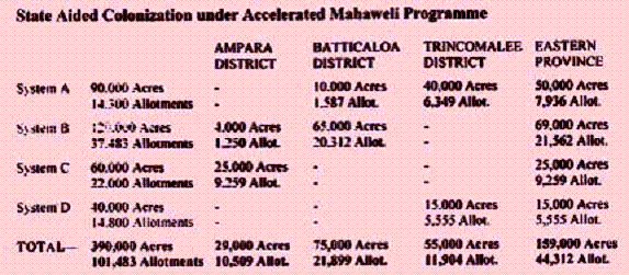
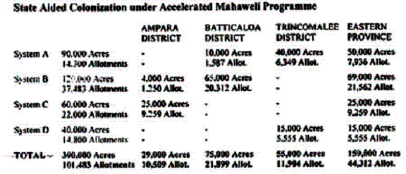
Under the Accelerated Mahaweli Programme, the land area coming under the Eastern Province is 159,000 acres or 44,312 allotments. More than 100,000 Sinhalese will be settled soon according to the new agenda. When the operation is commenced in the proposed Heda Oya Scheme in Pottuvil, Ampara District, the demography of the East will be changed to 55% Sinhalese. Allocation of land areas in the demarcation of electoral and administrative units The 1976 Delimitation Commission demarcated the Seruvila Electorate for the Sinhalese covering 700 sq. miles out of the 1048 sq. miles for the 24% Sinhalese in Trincomalee District. The land area for the 76% Tamils and Muslims was the balance 348 acres. According to 1971 census, the population of Ampara District - 47% Muslims, 30% Sinhalese, and 23% Tamils. The Ampara electorate created for the newly settled Sinhalese under the Gal Oya state aided colonisation is 880 sq. miles. With the 370 sq. miles allocated for the Lahugala and Damana AGA Division, the 30% Sinhalese were given 1,250 sq. miles- 70% land area, whereas the 70% Tamils and Muslims are left with only 30% of land area - 525 sq. miles. Former Muslim majority Panamapattu DRO Division, 472 sq. miles, population 26,916. When redemarcating the new administrative divisions, 19,831 - 74% Muslim majority Pottuvil AGA Division was given only 22% - 103.9 sq. miles and the balance 78% - 368.2 sq. miles land area was allocated for the 7,085 - 26% Sinhala majority Lahugala AGA division. In the Sammanthurai Muslim majority DRO division, nearly 50 sq. miles of land area covering the Hendy Institute, Ampara tank and town area was separated and added with the Wewagarnpattu South - Uhana AGA division. When comparing the land area of Sinhala majority Lahugala AGA division with the Muslim majority Kalmunai AGA division, the Sinhalese are having 208 times more than the land area of the Muslims. When comparing the land areas for the Sinhalese with the land area for the Muslims in the Muslim majority Ampara district, the Sinhalese land area is 13 times more. More than 65% of the people, Tamils and Muslims, [are] living in the coastal area of the Ampara district. But the Ampara kachcheri [government office] continues the administration in Sinhala quite contrary to the constitutional requirement of the language of administration in Tamil. Master plan There is an integrated development master plan for Trincomalee town and other surrounding areas. One of the proposed projects for Trincomalee under this plan is the special economic zone at Kappalthurai. The first phase costs Rs. 4,250 million and the second, Rs. 2,600 million. It will be completed in 2015. There will also be a small and medium industrial zone at Kappalthurai. The first phase costs Rs. 500 million and the second, Rs. 1,000 million. It will be set up in 2008. A new administrative secretariat will be established for Rs. 300 million in 2008. A new fisheries harbour costing Rs. 1,000 million is to be constructed by 2010 at Pudavaikattu. A new town development scheme for Andankulam-China Bay is to be built by 2010 for Rs. 1,500 million. A massive road project linking Uppuvely and Eechilampattu is to be constructed by 2010 for Rs. 10.3 billion. This proposed outer circular road will run through Sinhala areas of Seruwila division. This is an extension of a new road constructed in Trincomalee North. Two tourist resorts will be set up by 2010. They will be in Nilaweli and Verugal at a cost of Rs. 800 million and Rs. 1,750 million, respectively. The other important project is the coal-fired power plant to be set up with Indian assistance. Both phases of the project are expected to cost US$ 500 million each and will be completed by 2012. Originally it was earmarked for Kappalthurai but Colombo wanted to set it up later in Sampur. However, New Delhi has stood firm and it is likely to come up in Kappalthurai. The groundwork is being laid cleverly for future 'Sinhalaisation'. The Road Development Authority has begun constructing an inner ring road and an outer ring road for Trincomalee. The inner ring road links Aathimottai on the Trincomalee-Nilaweli-Pulmottai Road, Kinniya on the A 12 (Puttalam-Anuradhapura-Trincomalee Road) and 189km post on A-6 (Kandy-Habarana-Trincomalee Road). Encroachments The outer ring road planned will begin at Kuchchaveli on the Trincomalee-Nilaweli-Pulmottai Road, cross A12 near Pankulam and meet A6 between Kantalai and Tamplakamam and proceed to Ilankaiturai-Muhathuvaram and Sampur. The construction work is being undertaken by the Sri Lanka Army (SLA). The RDA Chief Engineer in Trincomalee works very closely with the SLA. The planning is done in Colombo. The Provincial Director of the RDA, based in Batticaloa is completely in the dark about the two ring road projects. Arrangements are being made for the Sinhalese 'encroachers' to move in between A-6 and A12 on this ring road. After de-merging the North and East in October 2006, the Eastern Province administration is being ethnically transformed. Former Trincomalee GAs, Rodrigo and Nelundeniya, are chief Secretary and Public Administration Secretary respectively. Former Matale GA, Udage, is now Secretary of the Provincial Public Services Commission. There are also many ex-servicemen in key positions. The Governor is Rear Admiral Mohan Wijewickrema. The GA is Major General Ranjith de Silva. The Rehabilitation Coordinator is Major General Amaradeva. The Governor's Secretary is Capt. Patrick Jayasinghe. Appointing ex-servicemen to key administrative posts has been criticized by members of the administrative service. However, the fact remains that this combination of retired administrative and security officials is well-equipped to implement the 'Sinhalaisation' process in the East.
| ||