| Development of water resources in the Eastern province |
| by G.T. Dharmasena, ‘The Island,’ Colombo, July 19, 2007
Former Director General of Irrigation and presently the Consultant to the United Nation’s Office for Project Services(UNOPS)
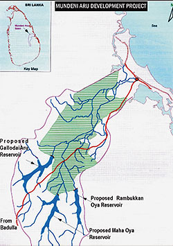
It is strongly believed that the prevailing internal war in the North and East during the last two decades can be successfully resolved with the devolution of political power and providing equitable resource distribution such as water. The shortage of natural resources such as water in the North and Eastern provinces and the non availability of job opportunities for the people to be engaged on economic activities in their areas can be seen as one of the roots of today’s problem. With that in mind the writer of this article is making an attempt to focus on the possible water resources development in the East as a pre req uisite to end the prevailing war. The possible surface water resources development in the Eastern Province, which includes the potential development of Heda Oya, Mundeni Aru, Maduru Oya and Yan Oya. The re-capture of Toppigala, at least for the moment, can be regarded as the end to the Tiger guerrilla dominance in the Eastern Province. There is no doubt that the victory at Toppigala is significant. One should not forget the fact that the success at Toppigala is built on the sacrifices of the dedicated troops. Some of them engaged in the battles are not living to see this achievement. In comparison to the some of the formal armed forces in Asian countries, the Security Forces and the Police, including the Special Task Force (STF) forces of Sri Lanka are distinctly different. Whatever the Government in power, whatever the task in hand they execute it with devotion and deep commitment with a sense of patriotism and responsibility. This is both during war and peace. This is exactly the reason for the success behind the victories in the battlefields during the recent past specifically in the Eastern Province. The Toppigala consists of stretches of scrub jungle, with rocky patches and therefore it is a good hiding ground. That is why the guerrillas used this almost inaccessible terrain to set up bases to re-train, re-arm and re-group to attack troops and police in the East. The surroundings of Toppigala offered them the protection they needed. These bases assumed greater significance after the fall of Mavil Aru, Sampur, Vakarai, Panichchankerni, Kathiraveli and neighbouring areas. However the LTTE’s presence in small pockets and movement from place to place can not be over ruled even in future. With the moral boost given by the ordinary people in the country for the forces and the police, now it would be more appropriate and important to consider the sustainability of this operation than the re-capturing of other areas, to make sure that the giant gains are retained and stabilized. For that in one hand one would require a large military and even police force to prevent guerrilla infiltration and the consequent destabilization of the development process mooted by the government. There is no doubt such arrangement for a longer period is not sustainable and expensive. Therefore only other hand stabilizing the civil administration and launching a massive development programme would be more strategically. The fall of major LTTE bases in the East would facilitate the ongoing resettlement and reconstruction works in the Eastern Province in a sustainable manner With that in mind this article focuses on the possible surface water resources development in the Eastern Province, which includes Ampara, Batticaloa and Trincomalee districts. The potential for development in this region had been studied by the Irrigation Department and the Mahaweli Authority during the last 20 to 30 years and several projects had been identified and conceptual plans were prepared. Therefore attention of the Honarable Ministers in charge of these ministries is required to direct the officials to unearth these plans to commence implementation during the next few years. a. Moragahakanda Development Project: Under the original UNDP Master Plan of 1968, five major reservoirs were proposed and the Kotmale, Victoria, Randenigala and Rantambe reservoirs have been completed. The fifth major reservoir yet to be constructed is Moragahakanda, which is across the Amban Ganga, a major tributary of Mahaweli Ganga. The Kalu Ganga is a tributary of the Amban Ganga and its confluence is below the Elahera anicut. A dam across the Kalu Ganga was also identified in the original Master plan and this reservoir is located in close proximity to Moragahakanda. Feasibility studies for the Moragahakanda reservoir were completed by Lahmeyer International consultant in the year 2000 and then the Kalu Ganga feasibility study was undertaken subsequently by the same consultant in 2004. The rationale behind the proposed Moragahakanda reservoir is to harness the unregulated water in the Amban Ganga basin to control the annual spillage over Elahera for the benefit of irrigation systems in Bakamuna, Elahera,Minneriya,Kaudulla and Kantale. The Moragahakanda reservoir will also supply the future drinking and industrial water requirements to Trincomalee and cut down the present water diversion at Polgolla. The reduction of Polgolla diversion has the advantage of developing enhanced hydro power by routing through Victoria and Randenigala b).Development of Maduru Oya right bank: The Maduru Oya basin has a drainage area of 1541.0 sq.kms and the Oya originates from Mahiyangana in the Badulla district. This river remained less developed until the restoration of the Vakaneri tank,Pimburatthawa tank and the Maduru Oya reservoir during the recent past. The Punani anicut across the Maduru Oya, irrigates lands on the left bank of Maduru Oya and the development of lands under the Maduru Oya reservoir constructed during the Mahaweli accelerated programme was also limited to the left bank mainly due to the conflicting situation. The Maduru Oya reservoir has a capacity of 598 mcm and it was designed for the development of both banks of the Maduru Oya. There is a large extent of flat fertile lands under rain fed cultivation extending from Welikanda to Valachchena on the right bank of the Maduru Oya in Batticalloo District. It is envisaged to develop further 10,000 ha. under Maduru Oya R.B. which is located in the Batticaloa District. The water presently available at the Maduru Oya reservoir is quite sufficient to provide irrigation water to the right bank as more than 800 mcm spills over the Minipe anicut every year. The Feasibility Study of this Project was carried out by ACRES International Ltd in August 1980, In 1982 ACRES carried out an update of technical and costing data with funds obtained from the Canadian International Development Agency (CIDA). Detailed designs of the right bank (RB) main and branch canals were carried out in late 1981 and in 1982 with USAID financing. c).Heda Oya reservoir: Heda Oya originates from the Moneragala district and flows to the sea at the eastern coast near Panama. It has 604.0 sq.kms of drainage area and the Oya is mostly untapped. The Muthukandiya reservoir is the only existing reservoir in the Heda Oya basin and it is located in the Monaragala district, but not across the main Heda Oya. The proposed reservoir site is located near Siyabalanduwa on the border of the Moneragala and Ampara districts and it has a capacity of 394 mcm. The proposed reservoir has irrigation benefits for 4000.ha of new lands in the Potuvil electorate in the Ampara District.The Irrigation Department commenced investigation works of Heda Oya as far back as 1922 and detailed plans have been now completed. d). Mundeni Aru River Basin: At present Mundeni Aru is untapped and it has no reservoirs across the main stream. The down stream reservoirs, Rugam and Unichchi are not across the main Mundeni Aru. It has a drainage area of 1280 sq.kms and the annual discharge to the sea in Batticaloa is of the order of 757.0 mcm. One of the major problems in the lower basin of Mundeni Aru is flooding in addition to the water shortage during the dry seasons. The Mundeni Aru in the upper reaches consists of three major tributaries located in the Ampara district. They are Rambaken Oya,Maha Oya and Gallodaithe Aru . There are three potential reservoir sites available across these tributaries to regulate the large amount of water to benefit 15000 ha of lands in the Batticaloa and Ampara districts. Such regulation of water prevents the flooding of the downstream valley in the Batticaloa district. The formulation of development plans for the Mundeni Aru basin was commenced in the early 1970’s,but none of these plans was implemented. The graphic shows the location of these three reservoirs. i.Rambaken Oya reservoir: The Rabaken Oya reservoir is across Rambaken Oya and has a catchment area of 130.0 sq.kms. The Irrigation Department has completed the feasibility studies and planning to commence the construction work soon. The Rambaken Oya reservoir has the capacity of 49.0 mcm and the potential of providing irrigation facilities for 2,400 ha. of farmland . ii. Maha Oya reservoir: The proposed reservoir across the Maha Oya and development area is located on the right bank of the Maha Oya. The gross acreage of about 7,000 ha. has been identified for development under irrigated agriculture. The proposed reservoir will have the capacity of 84.0 mcm. The area under development at present is mostly in jungle and a few people are engaged in occasional cultivation for their livelihood. iii.Gallodai Aru reservoir: The proposed development area is located on the left bank of the Galloadai Aru with a gross area of about 2,000 ha. The proposed reservoir has the capacity of 96.0 mcm. Topography, land use and soil condition of the area are almost the same as those of the afore-mentioned two schemes. The area is mostly covered in jungle with a few small village tanks for paddy cultivation. e).Yan Oya Development: The Yan Oya forms the natural boundary between the North Central Province and the Eastern Province and has a drainage are of 1520 sq.kms. The only major reservoir across Yan Oya is Hurulu Wewa . The annual discharge of Yan Oya to the sea has been estimated as 132 mcm. In order to harness this water going waste, a proposal was prepared to impound surplus water at a dam site at Pangurugaswewa, about 25 kms upstream from the river mouth. The original proposal was to benefit the Padaviya tank and the command area of Padaviya . However this proposal is now revived with a new concept of augmenting the water supply to existing minor tanks on both banks of Yan Oya. It has been identified that more than 1000 ha of lands can be provided with enhanced water by augmenting about 15 existing minor tanks. The pre feasibility study was done by the CECB to have a reservoir at Pangurugaswewa . The identification of a suitable conveying system to feed the network of above minor tanks has to be done. The provision of drinking water to the community in the area also has to be incorporated to the project to make the project multifunctional. Conclusion: In conclusion this article highlighted the available potential at four major water river basins in the Eastern province. The development of water resources in these basins have been conceptualized by deviating from the traditional sectoral approach. That is to say that these water resources projects have been planned for multiple use by providing water for drinking, hydro power, industries and environmental purposes, while assuring much needed agricultural water for food production. These aspects have been recognized by the Irrigation Department to make projects more economically viable. Therefore focus of the Honarable Ministers of Irrigation and Mahaweli and his top officials is required to promote these plans as the demand for such plans are awaiting. The development of water resources as explained above will be complementary to the intended permanent peace in the countr |
 At a moment the focus of all peace loving people of the country, irrespective of political divisions ,religions and races is on the magnificent victory of Toppigala, the general public admires the precise contribution of the forces and the police in the Eastern Province. According to the government media after this great victory, the government plans to resettle 14,000 people in newly liberated areas by spending more than 1,000 million rupees on various infrastructure development projects. In view of the above the author of this article makes an attempt to invite the attention of political authorities, administrators, professionals and the ordinary public who are concerned with these developments on the aspect of identification physical resources development for a long lasting solution to end this meaningless conflict. By laying of the foundation for Moragahakanda and Rabaken Oya major irrigation projects , the President Mahinda Rajapaksa made a significant and historic event. If properly planned the both of these events can be regarded as a strategy to end the prevailing unrest in the Northern and Eastern Regions of Sri Lanka by delivering the undeveloped water resources in the region for economic development.