A Published Note on Ptolemy’s Taprobana Map by C. Suntharalingam
by Sachi Sri Kantha, October 4, 2024
Front Note by Sachi

C. Suntharalingam (1895-1985)
Due to my protracted literature foraging activities on missed items by eminent bibliographer Henry Ian Goonetilleke (1922-2003), on Ceyloniana, recently I was able to locate a research note by mathematician Chellappah Suntharalingam (1895-1985) that was published in the Geographical Journal of December 1969. This item is missing in Goonetileke’s 5-volume compendium ‘Bibliography of Ceylon’ (1970-1983). Goonetileke had provided only an entry in vol. 4 to the typescript ‘Essays on early geographical history’ (1969), with an annotation “No title page. Cover title only. A folio typescript (carbon copy) in the Library of Congress. A collection of addresses, lectures and essays”. The above mentioned published research note was derived from this typescript.
For it’s value for historians, I reproduce the published text below verbatim. The letters in italics, are as in the original. Why Goonetileke’s vigilant eyes missed it? My impression is that, this particular research note lies ‘hidden’ in the Geographical Journal’s ‘THE RECORD’ column, with a sub-heading ‘The Early Geography of Ceylon’; but the author’s identity was not prominently displayed.
Politician Suntharalingam, the originator of the Eelam campaign (His idiosyncratic spelling was Eylom), had been faulted by many (including Tamils) for his missteps in political career and social activism. But I would consider this note on Ptolemy’s Taprobana map by Suntharalingam (the mathematician cum academic), is a vital scholastic contribution to cartography and onomastics of Sri Lankan/Eelam history. And it was considered meritorious for a short note in the Geographical Journal, as an annotation in its ‘The Record’ column.
It should be noted that Alexandrian cartographer Claudius Ptolemy (c. AD 100 – 170) prepared his geographical maps (circa AD 140-150) in Greek script. The currently prevalent maps of Ptolemy’s Latinized versions were prepared 1,000 years later in the 13th century, when Ptolemy’s Geography was translated into Latin, from the original Greek script. This was prior to the invention of movable printing press by Johannes Gutenberg in 1440. Thus, hand-made tracings were bound to have clerical errors made by scribes/translators, however diligently they had prepared the work for preservation. Suntharalingam had picked up such a type of error in Ptolemy’s Taprobana map, depicting the island, which came to be tagged by the name Ceylon in the 16th century.
In essence, Suntharalingam’s logic was that (1) Ptolemy’s Map of Taprobane has been made erroneous (warped) due to a clerical error of chart strip displacement, (2) This error in coordinates “has come down through the centuries in such a mutilated compilation owing to the misplacing of one or two chart-strips.” (3) Based on his ‘corrected reading of Ptolemy’s map’, Suntharalingam identifies Ptolemy noted locations of Ilankai as follows: Talacori empor = Island of Mannar, Modoti empor =Mahatittha in Pali Chronicle = current Mannar, Arubingara in the west coast = the Tamil name Arubi-nagaram meaning Arab town, Anurogrammon = modern Anuradhapura, and Spatana porto =modern Point Pedro.
For comprehension, I provide two Ptolemy maps of island Taprobana. One is in the original Greek script, which I found in J.R. Sinnatamby’s self-published 73 page book, entitled ‘Ceylon in Ptolemy’s Geography’ (1968). He was a deputy Surveyor General of Ceylon. The other one was the Latinized version, in which I’ve circled a few locations, indicated by Suntharalingam in his published research note of 1969.
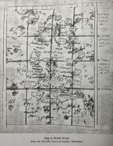
Ptolemy’s-Taprobana Map (Greek version, circa AD 150)
[FROM Geographical Journal, Dec 1969; 135(4): 636-638]
THE EARLY GEOGRAPHY OF CEYLON
An edition of Ptolemy’s Taprobana Ins. (or modern Ceylon) has come to light recently in Colombo, and has inspired Mr. C. Suntharalingam to write a series of essays under the general title of Essays on early geographical history of Eylom. Mr. Suntharalingam has most kindly agreed to the retention of his essays in the Society’s Library, and printed below are some points from the essays extracted for the Journal by the author.
In his preface, Mr. Suntharalingam states his purpose:
‘A chance discovery in the Archives of the Government of Ceylon of an edition of Ptolemy’s Taprobana Ins. with an unpublished descriptive legend, has resulted in these essays. The conclusions reached go counter to ideas and interpretations hitherto prevailing through the centuries in regard to the Map. In the view of the author of these Essays, the erroneous placing of a chart-strip in compiling the map, with consequential mistakes in the location of a few places in the northern and north-eastern regions of the island, has been responsible for much scholarly speculation, guess-work and controversy.
The original drawing of the map, without the grid lines of latitudes, longitudes and compartmentalized place-names, as shown in the Mount Athos MS Map, does not appear to have been given the consideration it deserves. But for the misplacing of the chart-strip, the original drawing gives probably the best picture of the island at the time of Onesicritos’ circumnavigation on the orders of Alexander the Great, c. BC 327-226.’
Mr. Suntharalingam points out that this circumnavigation provided the earliest material on which maps of the Portuguese-named island of Ceylon came to be compiled, and includes a note on the names by which the island has been known. The Greek spelling of the Island of Taprabane (τοπροb ονη), appears in the legend to the Mount Athos MS Map. Onesicritos had been ordered by Alexander to confer with the ‘Brahmin Gymnosophists’ who knew the Island by its Sanskrit name Tamraparni, this being derived from the Thamil ‘Thampiranpanni, ‘Pali-ised into Tambapanni. The name ‘Ceylon’ dates from 1505 AD, and represents an error by a Portuguese scribe. For a fuller discussion of nomenclature, see Suntharalingam, 1968. Most of the Latin and Greek names in the Map are transliterations of Thamil names.
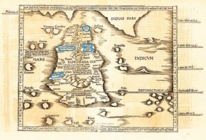
Ptolemy’s Taprobana Insula Map (Latin version), 13th century
Reasons for supposing the ‘erroneous placing of a chart-strip’ are summarized by Mr Suntharalingam in the following note.
‘Starting from the estuary of the Indus, Onesicritos would have voyaged southwards along the Malabar coast of India and reached the Cape shown in Ptolemy’s Map of India (Asiae Tab., first drawn in AD 150) as Commaria extrema. Rounding the cape, he would have coasted northwards until he reached Calignum promont. (see McCrindle, 1926), modern Point Calimir, near Rama’s bridge. Thence he would have turned eastward until he reached Cory Insula (Coast Island). This island is clearly the present-day Island of Mannar, passing which any coasting navigator must continue eastward to reach the mainland of Taprobane. In Ptolemy’s Map of India, Taprobane pars (part of Taprobane) nearest to Cory Insula is depicted, showing only four names: Boreum prom., Talacori emporium, Phasis flu, and Modoti emporium. It is thus clear that the three places and the river are nearest to the Island of Mannar on the Taprobane mainland; these are on the west coast, not the north, of Ceylon. The place-name Boreum prom. Is not shown in any of the Greek or Latin editions of Taprobane in the British Museum or Library of Congress – a significant omission. The name itself is Latin for north and it seems reasonable to infer that the promontory was indicated as Boreum by a navigator who assumed (erroneously) that it was the northernmost point of the Island.
Onesicritos, on reaching the mainland of Taprobane, would then southward, still hugging the coast, proceed from place to place, noting on strips of recording material there names as given to him by a guide. The starting point of each chart-strip and the ending point would be noted by the names of their respective places, and the succeeding chart-strip would have, as its starting point, the ending point of the previous strip. At a later date, the strips would be pieced together and the Map of the Island compiled. If the strips were disarranged or their sequence disturbed, the piecing together would result in a faulty map; the map would, in so far as the place-names are concerned, be a mutilated compilation of the corresponding regions.
It is submitted that Ptolemy’s Taprobana Ins. – Tabula XII Asiae – as it has come down through the centuries is such a mutilated compilation owing to the misplacing of one or two chart-strips. Firstly, it will be seen on an examination of all available editions of Ptolemy’s Map, the name of one place is spelt variously as Aurubingara, Aribingarara, Anubingara, also rendered Anubingara portus, Arubingaara Civitas. The name occurs twice, once on the west coast and again on the east. Commenting on this J.H.O. Paulusz states (Brohier, 1935) that ‘The duplication is evidently an error’. C.W. Nicholas in his Historical topography of ancient and medieval Ceylon (Nicholas, 1959) suggests that a ‘re-orientation of the Map is necessary’. It is submitted that the so-called ‘error’ and the suggested ‘re-orientation’ have arisen from misplacing the chart-strips starting with the name Galiba extr. and ending with Arubingara (which should be on the west coast only) with Galiba. (The spelling Arubingara is preferred because it is a transliteration of the Thamil name Arubi-nagaram meaning ‘Arab town). Its location on the west is thus determined as it corresponds to the neighbourhood of modern Puttalam which in ancient times was a settlement of Arab traders, and in recent times populated by Sonahar (Onesicritos’ Sonaal).
When the chart-strips are correctly placed on the west instead of the north and north-east, the names of places and the intervening river reached in the course of circumnavigation would be in the following order:
Talacori empor: ‘Talacori is a transliteration of the Thamil name meaning ‘Head coast’ nearest t the Island of Mannar. There is a place here called Talaidi. This fits well with the location as given in Taprobana pars, in Ptolemy’s Asiae X. Tab.
Phasis flu: There is no river corresponding to Phasis flu. Flowing northward having a range of mountains on its left bank. The rive, as suggested by Codrington (1926; see also Suntharalingam, 1968) corresponds to modern Aruvi Aru near the estuary,Kadambinadi near the middle and Malwatu Oya near the source, south of which the Sinhalese, called the Sale or Salai people in Ptolemy’s Map (who migrated to the Island in BC 543 (?483) were settling down. There is a range of hills, hillocks, etc. to the left of this river. In the Mount Athos MS Map a river named Sala Potomos is indicated flowing eastward from the southern end of this range. This river in all the editions of Ptolemy’s Map in Latin form, is called Ganges flu, leading to controversies hitherto unresolved. It is suggested that Sala Potomos is modern Malwatu Oya mistakenly placed in the chart-strip.
Modoti Empor: The name Modoti is a latinized transliteration of the Thamil Modotum – the first o is sounded as a, a common feature in Hellenized pronunciation. This emporium – or market – was, until the sixteenth century, the most famous centre of the entrepot trade between the Asiastic countries to the east, and the mid-east and western countries to the west of the Island. It is referred to as Mahatittha in the Pali Chronicles of the Island. The corrected location of the place fits well with what is given in Taprobane pars in Ptolemy’s Asiae X Tab.
Secondly, the correction would involve two consequent amendments in the Map:
Anurogrammon (Anura village, modern Anuradhapura) will have to be placed north of Sonaal Potomos in the Mouth Athos MS Map in Greek form and Soni flu. in the Latin
Editions – now Deduru Oya (?).
Spatana porto (modern Point Pedro) and Nagadipa (modern Jaffna peninsula) along with the small island to the west of it Nagadipa (of Buddha’s fame, modern Nagadivu or Nainativu) will have to be shifted to the northern coast instead of being in the north-east, and the small island will have to be shifted west.
The rest of the Map would remain unaltered, except for necessary adjustment of relative positions of places such as Trikon (modern Trincomalee) shown in the Mount Athos MS Map.
In a historical map (No. 75 (a)) of the Island found in the collection of Surveyor-General of Ceylon, two coastal places Sinus Bay and Anubingara appear both on the west and east coasts. The former is located south of the latter, both being situated at relatively equal distances apart. The configuration of Sinus Bay on both sides is identical. It is thus reasonable to infer that the chart-strip containing the two places and the Bay has been misplaced in the east as well. There is thus further justification for the correction.
It is hoped that the correction suggested will set at rest many of the controversies in regard to the identification of places, rivers, mountains and other features in Ptolemy’s Taprobana Insula, now ‘Ilankai, Lanka, Ceylon’.
References
Brohier R.L. 1935. Lands, maps and surveys vol. II, p. 24, Colombo.
Codrington H.W. 1926. Ceylon.
McCrindle J.W. 1926. Ancient India, as described by Megasthines and Arrian, pp. 6 off. Calcultta.
Nicholas C.W. 1959. Historical topography of ancient and medieval Ceylon. J. R. Asiat Soc., Ceyl. 6 (.N.S.)
Suntharalingam C. 1968. Essays on early geographical history of Eylom (Ceylon). Typescript, R.G.S. Library.
*****