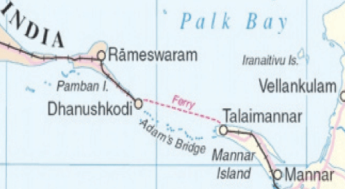
Both Sri Lanka and India are eager on going ahead with the proposed US $ 3.6 billion maritime bridge linking the two countries, The Sunday Leader reliably learns.
The relationship between Sri Lanka and India has been somewhat of a rollercoaster ride, with its own ups and downs, the relation has been varied from the stance of the governments which came into power from either side.
It is a known fact that the former government led by Mahinda Rajapaksa was more inclined towards establishing strong ties with China. Thus, a majority of the development projects which sprung up around the capital city were influenced by the Chinese government.
However, once the Ranil – Maithri government came to power, the financial community was interested to determine the new government’s foreign policy. Knowing that the United National Party had a good relationship with the west, and that the fact that the President was from the Sri Lanka Freedom Party, raised several concerns as to whether the previous relationship with China will be affected by the change of regime and its complexity.
The Indian government started conducting a feasibility study for the proposed US $ 3.6 billion road connectivity project between Sri Lanka and India during the latter part of last year.
The aforementioned road connectivity project was initially proposed by the Indian government as a symbol to represent the booming bilateral ties between the two countries. Upon enquiries The Island Financial Review reliably learns that the project possibly looks at direct road connectivity, built across Palk Strait, could possibly a combination of a sea-bridge and underwater tunnel with The underwater tunnel possibly allowing movement of ships through it.
Indian Union Minister for Road Transport, Highways and Shipping Nitin Gadkari speaking to international media on the matter confirmed that the Indian Government is considering initiating a road connectivity project between Sri Lanka and India.
Gadkari said that the distance between India’s Dhanushkodi in Rameswaram and the Sri Lankan boundary is about 23 km. According to him, the sea-bridge would help in increasing the road and transport trans-SAARC network. Dhanushkodi is situated south-east of Pamban town and approximately 29 km away from Talaimannar in Sri Lanka, which is also recognized as the town closest to the Indian land border.
According to the proposal, the Indian Government is planning a big flyover connecting Rameshwaram to Sri Lanka. Gadkari has said he had already held discussions with the Chairman of Asian Development Bank in this regard and the Bank is ready to finance the proposed project. The Indian Minister of Road Transport, Highways and Shipping also stated that this project is a part of Indian Prime Minister Narendra Modi’s vision of provisioning of road connectivity to neighbouring countries.
However, speaking to The Sunday Leader, reliable sources said that the Indian government is very keen on initiating the above venture as it will be a route to access the internal trade of Sri Lanka and a great medium for promoting bilateral trade relations. They said that after the proper feasibility studies conclude, the two governments will enter the next phase of the venture, the negotiations.
They reiterated that the venture will be mutually beneficial for both parties and that both parties will gain excellent exposure. The sources maintained that the Sri Lankan market will be able to expand with the resources made available by India.
As the country takes up an initiative to prosper as an emerging economy, expanding regional ties with the members of the SAARC will be a good platform to launch from. Since the government has been reaching out to the global investors and opportunities, initiating the above mentioned feature will be a step forward in the trade industry.
It was also learnt that the proposal for providing road and railway link bridging the divide across Palk Strait has been submitted to the Asian Development Bank (ADB) earlier in June. This was carried out as an aid for a pre-feasibility study and subsequent financing.
It is yet to be revealed as to when the project would commence and what would be the final figures in terms of expenditure. Reports also suggest that along with the SL – India road link, the Indian Government is also looking to connect to Thailand via Myanmar as well.
It is known that in the past also the two countries were connected across the Palk Strait and that it was a keystone in promoting bilateral trade between the two countries. Adam’s Bridge also known as Rama’s Bridge or Rama Setu, is a chain of limestone shoals, between Pamban Island, also known as Rameswaram Island, off the south-eastern coast of Tamil Nadu, India, and Mannar Island, off the north-western coast of Sri Lanka. Geological evidence suggests that this bridge is a former land connection between India and Sri Lanka.
The bridge is 30 miles (48 km) long and separates the Gulf of Mannar (southwest) from the Palk Strait (northeast). Some of the sandbanks are dry and the sea in the area is very shallow, being only 1 to 10 metres (3 to 30 ft) deep in places, which hinders navigation. It was reportedly passable on foot up to the 15th century until storms deepened the channel: temple records seem to say that Adam’s Bridge was completely above sea level until it broke in a cyclone in 1480.
Sources attached to the Asia Development Bank (ADB) said that India was mulling the project after ADB suggested that India look at a project linking with Sri Lanka. They stressed that the project would go ahead only after the finalisation of the feasibility project.The sources said that the commencement date could not be announced yet because the two countries are yet to enter the next phase of the operation. Furthermore they stressed that with Indu-Sri Lanka ties strengthening in the future, the project will gradually commence. On Sri Lanka’s part things seems to be on a silent track as there were not much discussions on the matter as at present.
